Severe Weather Outlook


new youtube channel - we've just launched a new experimental youtube channel over at tornado HQ, including severe weather outlook videos.
Severe Weather Watches Overview
Watch data currently updates every 15 minutes.

- EXPIRED Tornado Watch #0256 for North Florida and Panhandle, Southeast Georgia, Coastal Waters
-
- A couple tornadoes possible
- Scattered damaging wind gusts to 70 mph possible
- Isolated large hail events to 1.5 inches in diameter possible
↑ back to the list of watches ↑
EXPIRED Tornado Watch #0256
Locations Affected
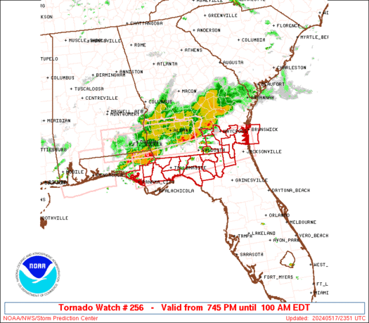
Tornado Watch Summary
A broken band of severe thunderstorms will move east-southeast into the Florida Panhandle and adjacent portions of southeast Georgia and north Florida during this evening. In addition to the risk for a couple of tornadoes, severe gusts 60-70 mph resulting in wind damage will be possible with any embedded supercells or bowing segments, as they move east-southeast across the Watch area.
Severe Weather Threats
Tornado Watch Details
SEL6

URGENT - IMMEDIATE BROADCAST REQUESTED
Tornado Watch Number 256
NWS Storm Prediction Center Norman OK
745 PM EDT Fri May 17 2024

The NWS Storm Prediction Center has issued a

* Tornado Watch for portions of
  North Florida and Panhandle
  Southeast Georgia
  Coastal Waters

* Effective this Friday night and Saturday morning from 745 PM
  until 100 AM EDT.

* Primary threats include...
  A couple tornadoes possible
  Scattered damaging wind gusts to 70 mph possible
  Isolated large hail events to 1.5 inches in diameter possible

SUMMARY...A broken band of severe thunderstorms will move
east-southeast into the Florida Panhandle and adjacent portions of
southeast Georgia and north Florida during this evening.  In
addition to the risk for a couple of tornadoes, severe gusts 60-70
mph resulting in wind damage will be possible with any embedded
supercells or bowing segments, as they move east-southeast across
the Watch area.

The tornado watch area is approximately along and 35 statute miles
north and south of a line from 25 miles south southeast of Brunswick
GA to 45 miles southwest of Marianna FL. For a complete depiction of
the watch see the associated watch outline update (WOUS64 KWNS
WOU6).

PRECAUTIONARY/PREPAREDNESS ACTIONS...

REMEMBER...A Tornado Watch means conditions are favorable for
tornadoes and severe thunderstorms in and close to the watch
area. Persons in these areas should be on the lookout for
threatening weather conditions and listen for later statements
and possible warnings.

&&

OTHER WATCH INFORMATION...CONTINUE...WW 253...WW 254...WW 255...

AVIATION...Tornadoes and a few severe thunderstorms with hail
surface and aloft to 1.5 inches. Extreme turbulence and surface wind
gusts to 60 knots. A few cumulonimbi with maximum tops to 450. Mean
storm motion vector 30030.

...Smith
National Risk Overview
- Saturday, May 18
- TORNADO: 2%
- HAIL: 5%
- WIND: 15%
- Sunday, May 19
- TORNADO: 5%
- HAIL: 15%
- WIND: 30%
- Monday, May 20
- ANY SEVERE: 15%
- Tuesday, May 21
- ANY SEVERE: 30%
- Wednesday, May 22
- ANY SEVERE: low / uncertain
- Thursday, May 23
- ANY SEVERE: 15%
- Friday, May 24
- ANY SEVERE: low / uncertain
- Saturday, May 25
- ANY SEVERE: low / uncertain
Your Severe Outlook
Hey, it looks like your location wasn't detected.
Drag the marker on the map and we'll show you the severe weather potential for a given location.
Hi, I'm Hayley. Did you know that I run this site out of my own pocket? So if you'd like to help out and you're already planning on buying something off of Amazon, why not use our Amazon Severe Weather Outlook link before you buy and we'll get a tiny portion of your purchase.
About Severe Weather Outlook . com
SWO started as a spinoff project of wickedwx, but has since replaced the site.
- tornado hq - live severe weather warnings
- cyclocane - hurricanes/typhoons/cyclones
- tornado solitaire - play cards while you monitor the US severe weather threat
- tertremo - live view of earthquakes around the world
- earthquake solitaire - get live earthquake updates as you play your favorite card game