Severe Weather Outlook
Hayley here - Do you like lofi music and terrifyingly loud computer voices? Then stop by the 24/7 ish severe weather live stream!
Outlook for Wednesday, July 3
Outlook Summary
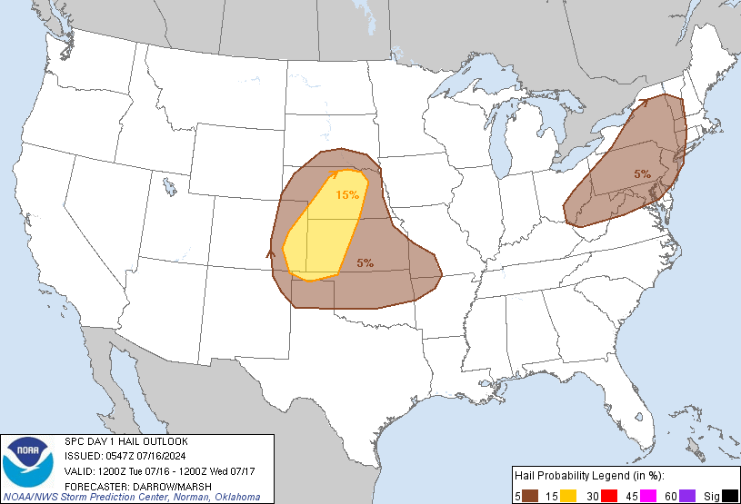
Scattered severe thunderstorms are possible across parts of the northern to central High Plains and from the Ozarks to Lower Ohio Valley, mainly from late afternoon to mid-evening. The most favorable corridor for isolated very large hail and significant severe wind gusts is centered on the central High Plains.
Outlook Images
Detailed Outlook
SPC AC 030550
Day 1 Convective Outlook NWS Storm Prediction Center Norman OK 1250 AM CDT Wed Jul 03 2024
Valid 031200Z - 041200Z
THERE IS A SLIGHT RISK OF SEVERE THUNDERSTORMS IN PARTS OF THE NORTHERN/CENTRAL HIGH PLAINS AND THE OZARKS TO LOWER OH VALLEY
### SUMMARY
Scattered severe thunderstorms are possible across parts of the northern to central High Plains and from the Ozarks to Lower Ohio Valley, mainly from late afternoon to mid-evening. The most favorable corridor for isolated very large hail and significant severe wind gusts is centered on the central High Plains.
Synopsis
A shortwave trough over the southern Canadian Rockies will dig southeast across the northern Rockies before reaching the north-central High Plains by early Thursday. As this occurs, a lee surface trough will sharpen over the High Plains. A convectively modified cold front will shift east-southeast into the Lower Great Lakes to the Ozarks. This front will remain quasi-stationary into the southern TX Panhandle, with the most prominent temperature gradient from here through northern OK owing to pronounced differential heating across OK to KS.
Central to northern High Plains
To the north of the southern Great Plains baroclinic zone, predominantly southeasterly low-level flow will attempt to advect richer moisture from southern/eastern KS. However, most 00Z models suggest increasing widespread convection from the TX/OK Panhandle into KS this morning amid low-level warm theta-e advection. This overturning will likely slow the northwestward moisture return. In addition, pervasive cloudiness will limit boundary-layer destabilization over the lower plains. These factors yield a probable confined plume of appreciable buoyancy and uncertainty over the amplitude of the peak buoyancy over the central High Plains.
Scattered thunderstorms will likely develop along the lee trough towards late afternoon, seemingly most probable from northeast CO to south of the Black Hills. An additional area/round of storms should also form farther northwest into northeast WY, ahead of the mid-level DCVA attendant to the approaching shortwave trough. Relatively modest low-level flow in conjunction with moderate to strong speed shear above 700 mb will yield moderate hodograph elongation. This should support widely spaced supercells capable of large to very large hail, and perhaps a couple tornadoes. Broken upscale growth with amalgamating convective outflows will probably occur during the early to mid-evening, which should yield a threat for isolated wind gusts of 70-80 mph. With potential for convection to spread relatively quickly into a cooler downstream boundary layer, confidence is too low to warrant a level 3-ENH threat this cycle.
Ozarks to the Lower OH Valley
Scattered thunderstorms will be possible along the weaker portion of the frontal zone during the latter half of the afternoon, aided in part by remnant MCVs from ongoing/forecast convection this morning. Along the fringe of modest mid-level southwesterlies, roughly parallel to the weak front, multicell clustering is anticipated. A threat for strong to localized severe gusts may be sufficient for potentially scattered wind damage.
..Grams/Squitieri.. 07/03/2024
CLICK TO GET WUUS01 PTSDY1 PRODUCT
NOTE: THE NEXT DAY 1 OUTLOOK IS SCHEDULED BY 1300Z
National Risk Overview
- Wednesday, July 3
- TORNADO: 5%
- HAIL: 15%
- WIND: 15%
- Thursday, July 4
- TORNADO: 2%
- HAIL: 5%
- WIND: 15%
- Friday, July 5
- ANY SEVERE: 5%
- Saturday, July 6
- ANY SEVERE: low / uncertain
- Sunday, July 7
- ANY SEVERE: low / uncertain
- Monday, July 8
- ANY SEVERE: low / uncertain
- Tuesday, July 9
- ANY SEVERE: low / uncertain
- Wednesday, July 10
- ANY SEVERE: low / uncertain
Your Severe Outlook
Hey, it looks like your location wasn't detected.
Drag the marker on the map and we'll show you the severe weather potential for a given location.
Hi, I'm Hayley. Did you know that I run this site out of my own pocket? So if you'd like to help out and you're already planning on buying something off of Amazon, why not use our Amazon Severe Weather Outlook link before you buy and we'll get a tiny portion of your purchase.
About Severe Weather Outlook . com
SWO started as a spinoff project of wickedwx, but has since replaced the site.
- tornado hq - live severe weather warnings
- cyclocane - hurricanes/typhoons/cyclones
- tornado solitaire - play cards while you monitor the US severe weather threat
- tertremo - live view of earthquakes around the world
- earthquake solitaire - get live earthquake updates as you play your favorite card game


