Severe Weather Outlook
Hayley here - Do you like lofi music and terrifyingly loud computer voices? Then stop by the 24/7 ish severe weather live stream!
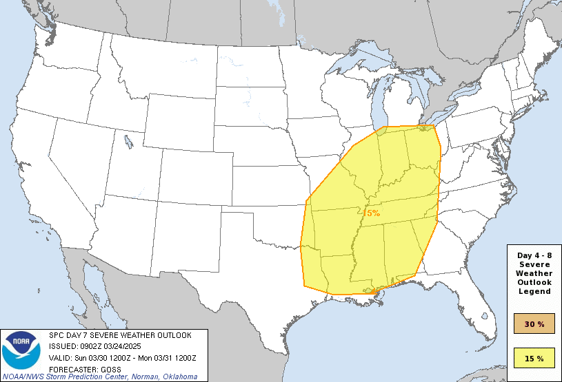
Outlook for Tuesday, December 17
Outlook Images
Note on Medium Range Outlooks
You are looking at an outlook that is part of the medium range forecast (the outlook for days 4-8). The most important thing to note is that lack of a risk does not mean zero risk. Generally speaking, confidence has to be pretty high for the Storm Prediction Center to have an outlook area this far into the future.
If you bookmark this page, it will continue to update with each new outlook that is issued.
Detailed Outlook
ZCZC SPCSWOD48 ALL ACUS48 KWNS 110948 SPC AC 110948
Day 4-8 Convective Outlook NWS Storm Prediction Center Norman OK 0348 AM CST Wed Dec 11 2024
Valid 141200Z - 191200Z
DISCUSSION
A progressive upper pattern is expected in the extended, with several low-amplitude shortwave troughs forecast to traverse the CONUS. Lead shortwave in this series will likely be over the central Plains on D4/Saturday morning before then moving through the Mid MS Valley by late D4/Saturday and through the OH Valley on D5/Sunday. Another shortwave is expected to follow in the wake of the first, progressing across the Great Basin and Four Corners on D5/Sunday and the southern/central Plains on D6/Monday. This wave may phase with another shortwave moving through central Canada, with resultant troughing extended from the Canadian Prairies into the southern Plains by D6/Monday afternoon. Yet another shortwave is currently progged to drop from the Pacific Northwest/northern CA into the Great Basin late D6/Monday. Guidance varies significantly on the evolution of this wave, and its strength/maturity and location currently have limited predictability.
Moisture return is anticipated across the Plains ahead of each of these waves. Enough moisture and buoyancy should exist ahead of the first shortwave to support thunderstorms, as it moves eastward on into the MS Valley on D4/Saturday and through the remainder of the eastern CONUS on D5/Sunday.
The most significant moisture return is currently expected ahead of the second shortwave on D5/Sunday and D6/Monday. Thunderstorms are likely as the shortwave and associated cold front interact with this return moisture, although variability within the guidance of the strength and speed of this wave results in differing areas of highest thunderstorm coverage. Some severe appears possible, particularly if the wave is stronger and further south as suggested by the 00Z ECMWF.
..Mosier.. 12/11/2024
CLICK TO GET WUUS48 PTSD48 PRODUCT
National Risk Overview
- Wednesday, December 11
- TORNADO: low
- HAIL: low
- WIND: low
- Thursday, December 12
- TORNADO: low
- HAIL: low
- WIND: low
- Friday, December 13
- ANY SEVERE: low
- Saturday, December 14
- ANY SEVERE: low / uncertain
- Sunday, December 15
- ANY SEVERE: low / uncertain
- Monday, December 16
- ANY SEVERE: low / uncertain
- Tuesday, December 17
- ANY SEVERE: low / uncertain
- Wednesday, December 18
- ANY SEVERE: low / uncertain
Your Severe Outlook
Hey, it looks like your location wasn't detected.
Drag the marker on the map and we'll show you the severe weather potential for a given location.
Hi, I'm Hayley. Did you know that I run this site out of my own pocket? So if you'd like to help out and you're already planning on buying something off of Amazon, why not use our Amazon Severe Weather Outlook link before you buy and we'll get a tiny portion of your purchase.
About Severe Weather Outlook . com
SWO started as a spinoff project of wickedwx, but has since replaced the site.
- tornado hq - live severe weather warnings
- cyclocane - hurricanes/typhoons/cyclones
- tornado solitaire - play cards while you monitor the US severe weather threat
- tertremo - live view of earthquakes around the world
- earthquake solitaire - get live earthquake updates as you play your favorite card game

