Severe Weather Outlook
Hayley here - Do you like lofi music and terrifyingly loud computer voices? Then stop by the 24/7 ish severe weather live stream!
Outlook for Sunday, February 9
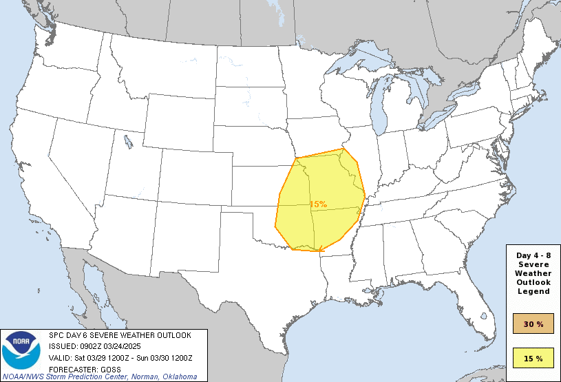
Outlook Images
Note on Medium Range Outlooks
You are looking at an outlook that is part of the medium range forecast (the outlook for days 4-8). The most important thing to note is that lack of a risk does not mean zero risk. Generally speaking, confidence has to be pretty high for the Storm Prediction Center to have an outlook area this far into the future.
When no specific risk areas are shown, you might see one of these phrases:
- Predictability Too Low: This means that severe storms might be possible, but forecasters aren't confident enough about where or when they might occur. Think of it as the models showing different possibilities, like pieces of a puzzle that haven't come together yet.
- Potential Too Low: This means forecasters are fairly confident that widespread severe weather is NOT expected on that day. While isolated storms might still occur, the chance of reaching severe criteria across any given area is very low.
If you bookmark this page, it will continue to update with each new outlook that is issued.
Detailed Outlook
ZCZC SPCSWOD48 ALL ACUS48 KWNS 040959 SPC AC 040959
Day 4-8 Convective Outlook NWS Storm Prediction Center Norman OK 0359 AM CST Tue Feb 04 2025
Valid 071200Z - 121200Z
DISCUSSION
Medium-range models are in reasonably good agreement through day 6 (Sunday), in terms of large-scale features. Substantial divergence begins thereafter, casting substantial uncertainty into the forecast beyond the upcoming weekend.
Day 4, as an upper short-wave trough crossing the Northeast moves into/across the Canadian Maritimes, the quasi-zonal flow pattern over the U.S. will continue. Weak amplification of the flow will occur over the West with time, however, as a short-wave trough moves across the Rockies. As this occurs, frontal low development is expected along the persistent west-to-east front lying from the southern Plains to the Mid-Atlantic region. However, with only weak instability expected near the developing low, and eastward along the front, convection is forecast to remain disorganized.
Day 5, the upper wave is forecast to continue eastward across the central and northern Plains through the day, and into and across the Great Lakes region overnight. The associated frontal low – initially progged to lie over the Oklahoma vicinity, will deepen as it shifts east-northeastward with time, reaching the northeast through the end of the period. The trailing surface front will sharpen and advance southeastward, extending from the Mid-Atlantic region southwestward to coastal Texas late. While showers and a few thunderstorms will be associated with the frontal advance, weak instability anticipated at this time should again hinder convective intensity.
Day 6, as the low moves offshore and the front continues advancing steadily southeastward, it should clear the Atlantic and Gulf Coasts during the evening, lingering only across Florida through the end of the period. The continued trend of weak instability, as well as weakening flow with southward extent, should hinder prospects for more robust convection.
..Goss.. 02/04/2025
CLICK TO GET WUUS48 PTSD48 PRODUCT
National Risk Overview
- Wednesday, February 5
- TORNADO: 2%
- HAIL: low
- WIND: 5%
- Thursday, February 6
- TORNADO: low
- HAIL: low
- WIND: low
- Friday, February 7
- ANY SEVERE: low
- Saturday, February 8
- ANY SEVERE: potential too low
- Sunday, February 9
- ANY SEVERE: potential too low
- Monday, February 10
- ANY SEVERE: predictability too low
- Tuesday, February 11
- ANY SEVERE: predictability too low
Your Severe Outlook
Hey, it looks like your location wasn't detected.
Drag the marker on the map and we'll show you the severe weather potential for a given location.
Hi, I'm Hayley. Did you know that I run this site out of my own pocket? So if you'd like to help out and you're already planning on buying something off of Amazon, why not use our Amazon Severe Weather Outlook link before you buy and we'll get a tiny portion of your purchase.
About Severe Weather Outlook . com
SWO started as a spinoff project of wickedwx, but has since replaced the site.
- tornado hq - live severe weather warnings
- cyclocane - hurricanes/typhoons/cyclones
- tornado solitaire - play cards while you monitor the US severe weather threat
- tertremo - live view of earthquakes around the world
- earthquake solitaire - get live earthquake updates as you play your favorite card game

