Severe Weather Outlook


new youtube channel - we've just launched a new experimental youtube channel over at tornado HQ, including severe weather outlook videos.
Severe Weather Watches Overview
Watch data currently updates every 15 minutes.

- Severe Thunderstorm Watch #0257 for Western Upper Michigan, Minnesota Arrowhead, Central and Northern Wisconsin, Lake Superior
-
- Scattered damaging wind gusts to 70 mph possible
- Scattered large hail events to 1.5 inches in diameter possible
↑ back to the list of watches ↑
Severe Thunderstorm Watch #0257
Locations Affected
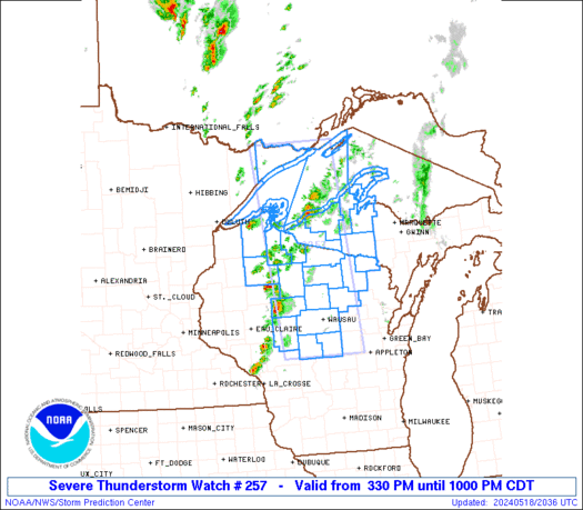
Severe Thunderstorm Watch Summary
Thunderstorms are developing along a cold front over western Wisconsin and northeast Minnesota. These storms will track eastward through the early evening, posing a risk of hail and damaging winds.
Severe Weather Threats
Severe Thunderstorm Watch Details
SEL7

URGENT - IMMEDIATE BROADCAST REQUESTED
Severe Thunderstorm Watch Number 257
NWS Storm Prediction Center Norman OK
330 PM CDT Sat May 18 2024

The NWS Storm Prediction Center has issued a

* Severe Thunderstorm Watch for portions of
  Western Upper Michigan
  Minnesota Arrowhead
  Central and Northern Wisconsin
  Lake Superior

* Effective this Saturday afternoon and evening from 330 PM until
  1000 PM CDT.

* Primary threats include...
  Scattered damaging wind gusts to 70 mph possible
  Scattered large hail events to 1.5 inches in diameter possible

SUMMARY...Thunderstorms are developing along a cold front over
western Wisconsin and northeast Minnesota.  These storms will track
eastward through the early evening, posing a risk of hail and
damaging winds.

The severe thunderstorm watch area is approximately along and 50
statute miles east and west of a line from 30 miles north northeast
of Grand Marais MN to 35 miles south of Mosinee WI. For a complete
depiction of the watch see the associated watch outline update
(WOUS64 KWNS WOU7).

PRECAUTIONARY/PREPAREDNESS ACTIONS...

REMEMBER...A Severe Thunderstorm Watch means conditions are
favorable for severe thunderstorms in and close to the watch area.
Persons in these areas should be on the lookout for threatening
weather conditions and listen for later statements and possible
warnings. Severe thunderstorms can and occasionally do produce
tornadoes.

&&

AVIATION...A few severe thunderstorms with hail surface and aloft to
1.5 inches. Extreme turbulence and surface wind gusts to 60 knots. A
few cumulonimbi with maximum tops to 500. Mean storm motion vector
26030.

...Hart
National Risk Overview
- Saturday, May 18
- TORNADO: 2%
- HAIL: 15%
- WIND: 15%
- Sunday, May 19
- TORNADO: 5%
- HAIL: 15%
- WIND: 30%
- Monday, May 20
- ANY SEVERE: 15%
- Tuesday, May 21
- ANY SEVERE: 30%
- Wednesday, May 22
- ANY SEVERE: low / uncertain
- Thursday, May 23
- ANY SEVERE: 15%
- Friday, May 24
- ANY SEVERE: low / uncertain
- Saturday, May 25
- ANY SEVERE: low / uncertain
Your Severe Outlook
Hey, it looks like your location wasn't detected.
Drag the marker on the map and we'll show you the severe weather potential for a given location.
Hi, I'm Hayley. Did you know that I run this site out of my own pocket? So if you'd like to help out and you're already planning on buying something off of Amazon, why not use our Amazon Severe Weather Outlook link before you buy and we'll get a tiny portion of your purchase.
About Severe Weather Outlook . com
SWO started as a spinoff project of wickedwx, but has since replaced the site.
- tornado hq - live severe weather warnings
- cyclocane - hurricanes/typhoons/cyclones
- tornado solitaire - play cards while you monitor the US severe weather threat
- tertremo - live view of earthquakes around the world
- earthquake solitaire - get live earthquake updates as you play your favorite card game